Insects, birds, and turbulence
Matti Leskinen 1998-02-23
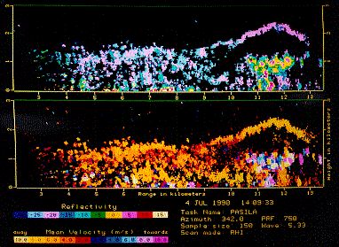
The radar measurements on July 4,1990 at 14:09 local summer time are displayed as vertical cross sections towards NNW. The radar of the Department of Meteorology is located on the left so that the measurements start at 3 km range continuing to about 13 km range. Vertical scale is from zero to 3 km heigth above radar (40 metres above sea level). Upper picture shows the echo intensity (dBZ), and the lower picture radial velocity (m/s).
There was a horizontal roll vortice at about 10-13 km range, and many birds were causing the echoes in the uplift zone. These are recognizeable as small round shaped echo areas with strongest echo intensities; at these ranges the transmitter pulse shape and antenna beamwidth result in echo areas having practically a shape of a ball. At the same time the measured radial velocity of the birds can be seen to vary a lot, and especially to differ much from the velocities of the other echoes.
The arc shaped echo line on top of the bird echoes was probably related to turbulence at the collision zone between the rising air and the stable air on top of the boundary layer. Otherwise the echoes were related to quite large insects observed almost as good as the birds, but much weaker and with nearly uniform velocity. The birds in the rising air were obviously feeding on smaller insects that were gathered to the convergence zone, but were masked in the radar mesurement by the enermously stronger echoes related to birds.
Change page to:
[clear air echoes]
[insect migrations]
[aphid migrations]
[Matti Leskinen]
[Department of Meteorology]