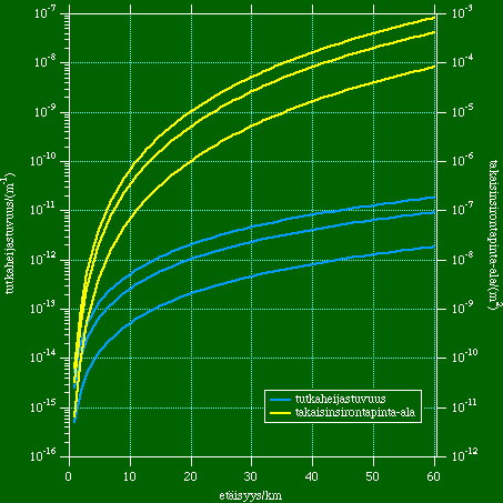
The calculated minimum detectable radar reflectivity and radar cross-section for Tuulia is shown in the figure below; the curves are up to 60 km range from radar, which is quite a typical maximum range of clear air echoes in optimal cases. The lowest values correspond the noise level of the radar receiver and other two normally used threshold values to filter out random noise points from data.
The scale on the left hand side axis is for radar reflectivity (blue curves) in 1/metre and the scale for the right hand side axis is radar cross section (yellow curves) in square metres.
The radar cross-section can be compared to some measurement based calculated values for insects: bee 7e-6 and mosquito 6e-9 square metres. This would mean that one mosquito can be observed at about 3 km range, and one bee at about 15 km range. Actual radar echo is usually a sum of echoes for many targets, since echoes are coming to the receiver simultaneously from a volume that is some millions of cubic meters. Normally weather radar signal processing averages the echo power from many successive pulses, and the resulting radar reflectivity is used for estimating precipitation intensity etc. Using the same principle on echoes from many insects in the radar measurement volume is also possible. An example of how radar echo intensity is interpreted as mean distances between insects of different sizes has been done using a vertical cross section of radar echoes southeast from Helsinki in late August, 1997.
Radar reflectivity values seen on the left hand side axis hapeens to be approximately the same value as refractive index turbulence structure parameter (in SI-units) due to the wavelength of the radar. Its usual range of variations has been calculated to be 2e-15...3e-14, which is not very high compared to the radar detection limit. However, turbulence in layers that have sharp refractive index gradient seem to cause well detectable echos as can be seen from the measurements of a roll vortice on May 20th, 1992. On the other hand using Kivenlahti suction trap catches the radar reflectivity can be estimated to be of the order of 1e-12 1/m. This is a value that is quite well suited to the actual radar observations, especially if one takes into account the fact that the trap catches are an average diurnally and seasonally from the beginning of May to the end of September. The clear air echoes have their maximum typically on midday and midsummer.
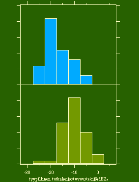 During 1986-1987 the distributions of typical equivalent radar reflectivity factor at daytime (usually early afternoon) is presented in the figure on the right. The estimation has been subjective and corresponds a height of about 200 m above the ground. Blue columns are for the southeastern sector from Helsinki that lies over the Gulf of Finland having some islands, and the green columns are for the land areas northwest from Helsinki. The equivalent radar reflectivity factor is a direct transformation of radar reflectivity and these have about following correspondences:
-25 dBZ = 1e-13 1/m
-15 dBZ = 1e-12 1/m
This means that the echo level estimated from the trap catches would be about -15 dBZ. The common threshold used for light rain has been 0 dBZ, but the maximum of clear air echoes have been 10 dB i.e. one order of magnitude stronger.
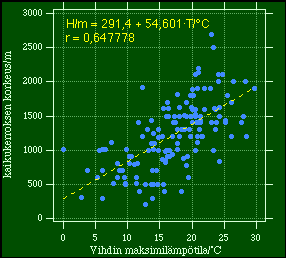 The observed clear air echo layer thickness is presented in the figure on the left in relation to the diurnal maximum temperature at a nearby weather station. Bird echoes have been excluded, of course, but the highest levels may have had some low level clouds that may cause echoes that rise above the detection limit. Typically low level clouds that are observed by the weather radar are some Stratocumulus layers, and thick Cumulus/Cumulonimbus type of clouds. Thinner clouds can be observed as echoless layers in cases where the cloud layer is inside clear air echo (i.e. insect) layer!
Generally the echo layer is about 1-2 km thick in the summer. The exceptionally cold cases are probably related to turbulence (also rising dust) and not insects.
The regression line with Pearson's correlation coefficient is also given.
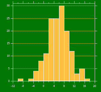 Using the diurnal maximum surface temperature and temperature lapse rate of 10°C/km it is possible to compare the echo layer thickness to the estimated temperature at that level. The lapse rate of temperature is approximately valid for summertime convective conditions. The result as a distribution of cases is presented in the figure on the right.
Some special cases have had a higher separate layer consisting of individual big insects flying near freezing temperatures at a height around 3 km above ground level (in Southern Finland the ground level is generally under 100 metres above sea level). These insects are believed to be moths that are able to maintain their body temperature well above the surrounding air temperature. On the other hand radio soundings in these situations have indicated inversion/cloud layers under these insects, which may cause them to continue flight.
[Matti Leskinen] [Matti Leskinen in Finnish] [Department of Meteorology]